Questões Militares
Para pm-pr
Foram encontradas 865 questões
Resolva questões gratuitamente!
Junte-se a mais de 4 milhões de concurseiros!


As formas ou conjuntos de formas de relevo participam da composição das paisagens em diferentes escalas. Relevos de grandes dimensões, ao serem observados em um curto espaço de tempo, mostram aparência estática e imutável; entretanto, estão sendo permanentemente trabalhados por processos erosivos ou de posicionais, desencadeados pelas condições climáticas existentes. Esses processos, originados pelas forças exógenas, promovendo, ao longo de grandes períodos de tempo, a degradação (erosão) das áreas topograficamente elevadas e a agradação (deposição) nas áreas topograficamente baixas, conduzem a uma tendência de nivelamento da superfície terrestre. Isso só se completará caso não haja interferência das forças endógenas, que podem promover soerguimentos ou rebaixamentos terrestres. Há que se considerar, ainda, a ação conjunta das duas forças e as implicações altimétricas geradas por ocorrências de variações do nível do mar.
Adaptado de MARQUES, J.S. Ciência Geomorfológica. In: GUERRA, A. J. T.; CUNHA, S. B. (Orgs.)
Geomorfologia: uma atualização de bases e conceitos. Rio de Janeiro: Bertrand,1994, p. 23-45.
Tendo como referência o texto acima e os conhecimentos de geomorfologia, a ciência que estuda as formas do relevo, identifique as seguintes afirmativas como verdadeiras (V) ou falsas (F):
( ) O relevo é o resultado da atuação das chamadas forças endógenas e exógenas. Os processos endógenos estão associados à dinâmica das Placas Tectônicas e os exógenos relacionados à atuação climática.
( ) Durante a era Cenozoica, as formas de relevo, em grande escala, permaneceram estáveis em consequência do equilíbrio entre forças exógenas e endógenas.
( ) Os deslizamentos de terra, fluxos de lama e detritos, que ocorrem em grandes maciços rochosos, como é o caso da Serra do Mar, apesar de resultarem muitas vezes em catástrofes e danos à população, podem ser processos naturais de degradação, que participam da evolução das formas do relevo.
( ) Os processos de agradação ocorrem predominantemente no Brasil em relevo de planícies.
Assinale a alternativa que apresenta a sequência correta, de cima para baixo.
A BRF, dona das marcas Sadia e Perdigão, foi condenada a pagar indenização por dano moral coletivo de R$ 1 milhão por condições degradantes de trabalho. A condenação é resultado da ação do Ministério Público do Trabalho (MPT) em Umuarama (PR), ajuizada em 2012, após investigação que flagrou trabalhadores em condições análogas à escravidão […] No início de 2012, o MPT-PR em Umuarama constatou graves irregularidades trabalhistas na Fazenda Jaraguá, em Iporã. Os problemas iam desde jornada excessiva e condições precárias dos alojamentos, até a contaminação da água fornecida aos trabalhadores para consumo. “A situação encontrada configura trabalho degradante, já que foram desrespeitados os direitos mais básicos da legislação trabalhista, causando repulsa e indignação, o que fere o senso ético da sociedade”, afirma o procurador do Trabalho Diego Jimenez Gomes, responsável pelo caso. A BRF é uma gigante do ramo de produtos alimentícios que surgiu a partir da fusão entre Sadia e Perdigão, além de ser detentora de marcas como Batavo, Elegê e Qualy. A empresa tem 49 fábricas em todas as regiões do País e mais de 100 mil funcionários. Em 2013, a receita líquida foi R$ 30,5 bilhões e o lucro líquido consolidado foi de R$ 1,1 bilhão.
Portal Instituto Unisinos, 29 ago.2014. Disponível em: http://www.ihu.unisinos.br/noticias/534749.
Com base no texto e no conhecimento de geografia agrária, assinale a alternativa correta.
Segundo o geógrafo Carlos Augusto de Figueiredo Monteiro, diferentes centros de ação atmosférica atuam sobre a América do Sul, sendo eles: Massa Tropical Atlântica, Massa Equatorial Continental, Massa Polar Atlântica, Massa Tropical Continental e Massa Equatorial do Atlântico Norte. Com base na atuação dessas massas de ar e em suas características, considere as seguintes afirmativas:
1. A Massa Equatorial Continental é a única massa continental do planeta com características úmidas, devido à grande extensão da floresta amazônica e sua evapotranspiração.
2. A Massa Polar Atlântica é a responsável pelas ondas de frio que atingem o Brasil devido ao abastecimento polar proveniente do Ártico.
3. A direção predominante dos ventos originados na Massa Tropical Atlântica sobre a fachada sul do Brasil é de oeste.
4. As massas Tropical Atlântica e Equatorial do Atlântico Norte são as formadoras, respectivamente, dos alísios de sudeste e nordeste que atuam sobre o Brasil.
Assinale a alternativa correta.
A população brasileira atingiu 202,7 milhões de pessoas em primeiro de julho deste ano, segundo estimativa do IBGE [...] O volume de pessoas que vivem no país cresceu 0,86% em relação ao verificado em igual período do ano anterior. São Paulo continua sendo a cidade mais populosa do país, com 11,9 milhões de habitantes. Em seguida, no ranking de cidades, vêm Rio de Janeiro (6,5 milhões), Salvador (2,9 milhões), Brasília (2,9 milhões) e Fortaleza (2,6 milhões). Os 25 municípios mais populosos do país somam 51 milhões de habitantes e representam 25,2% da população.
http://www1.folha.uol.com.br/cotidiano/2014/08/1507099-populacao-brasileira-atinge-2027-
milhoes-de-habitantes-calcula-ibge.shtml. Acesso em 02 set. 2014
Com base nos conhecimentos de geografia da população, assinale a alternativa correta.
As coordenadas a seguir são necessárias para o deslocamento do ponto 1 para o 5:
Ponto 1 – Lat.: 25º25’03,56” S e Long.: 49º15’37,15” W.Gr.
Ponto 2 – Lat.: 25º25’03,01” S e Long.: 49º15’32,03” W.Gr.
Ponto 3 – Lat.: 25º25’07,31” S e Long.: 49º15’33,77” W.Gr.
Ponto 4 – Lat.: 25º25’14,16” S e Long.: 49º15’24,17” W.Gr.
Ponto 5 – Lat.: 25º25’11,91” S e Long.: 49º15’23,01” W.Gr.
Com base nas coordenadas dos pontos de ligação entre 1 e 5 é correto afirmar que as direções a serem seguidas para realizar o trajeto são:
O Brasil apresenta uma situação confortável, em termos globais, quanto aos recursos hídricos. A disponibilidade hídrica per capita, determinada a partir de valores totalizados para o País, indica uma situação satisfatória [...]. Entretanto, apesar desse aparente conforto, existe uma distribuição espacial desigual dos recursos hídricos no território brasileiro. [...] O conhecimento da distribuição espacial da precipitação e, consequentemente, o da oferta de água, é de fundamental importância para determinar o balanço hídrico nas bacias brasileiras.
http://arquivos.ana.gov.br/institucional/spr/conjuntura/webSite_relatorioConjuntura/projeto/index.html.,
p.37. Acesso em 09 set. 2014
Sobre o uso, gestão e disponibilidade dos recursos hídricos no país, assinale a alternativa INCORRETA.
By Nick Allen
9:04PM BST 16 Aug 2013
Climate scientists have concluded that temperatures could jump by up to 5°C and sea levels could rise by up to 82 cm by the end of the century, according to a leaked draft of a United Nations (UN) report.
The UN Intergovernmental Panel on Climate Change (IPCC) also said there was a 95 per cent likelihood that global warming is caused by human activities. That was the highest assessment so far from the IPCC, which put the figure at 90 per cent in a previous report in 2007, 66 per cent in 2001, and just over 50 per cent in 1995.
Reto Knutti, a professor at the Swiss Federal Institute of Technology in Zurich, said: “We have got quite a bit more certain that climate change is largely man-made. We’re less certain than many would hope about the local impacts.” The IPCC report, the first of three in 2013 and 2014, will face intense scrutiny particularly after errors in the 2007 study, which wrongly predicted that all Himalayan glaciers could melt by 2035.
Almost 200 governments have agreed to try to limit global warming to below 2°C above pre-industrial times, which is seen as a threshold for dangerous changes including more droughts, extinctions, floods and rising seas that could swamp coastal regions and island nations. Temperatures have already risen by 0.8°C since the Industrial Revolution.
The report will say there is a high risk global temperatures will rise by more than 2°C this century. They could rise anywhere from about 0.6°C to almost 5°C a wider range at both ends of the scale than predicted in the 2007 report. It will also say evidence of rising sea levels is “unequivocal”. The report projects seas will rise by between 30 cm and 82 cm by the late 21st century. In 2007 the estimated rise was between 18 cm and 58 cm, but that did not fully account for changes in Antarctica and Greenland.
Scientists say it is harder to predict local impacts. Drew Shindell, a Nasa scientist, said: “I talk to people in regional power planning. They ask, 'What’s the temperature going to be in this region in the next 20 to 30 years, because that’s where our power grid is?’ We can’t really tell.”
By Nick Allen
9:04PM BST 16 Aug 2013
Climate scientists have concluded that temperatures could jump by up to 5°C and sea levels could rise by up to 82 cm by the end of the century, according to a leaked draft of a United Nations (UN) report.
The UN Intergovernmental Panel on Climate Change (IPCC) also said there was a 95 per cent likelihood that global warming is caused by human activities. That was the highest assessment so far from the IPCC, which put the figure at 90 per cent in a previous report in 2007, 66 per cent in 2001, and just over 50 per cent in 1995.
Reto Knutti, a professor at the Swiss Federal Institute of Technology in Zurich, said: “We have got quite a bit more certain that climate change is largely man-made. We’re less certain than many would hope about the local impacts.” The IPCC report, the first of three in 2013 and 2014, will face intense scrutiny particularly after errors in the 2007 study, which wrongly predicted that all Himalayan glaciers could melt by 2035.
Almost 200 governments have agreed to try to limit global warming to below 2°C above pre-industrial times, which is seen as a threshold for dangerous changes including more droughts, extinctions, floods and rising seas that could swamp coastal regions and island nations. Temperatures have already risen by 0.8°C since the Industrial Revolution.
The report will say there is a high risk global temperatures will rise by more than 2°C this century. They could rise anywhere from about 0.6°C to almost 5°C a wider range at both ends of the scale than predicted in the 2007 report. It will also say evidence of rising sea levels is “unequivocal”. The report projects seas will rise by between 30 cm and 82 cm by the late 21st century. In 2007 the estimated rise was between 18 cm and 58 cm, but that did not fully account for changes in Antarctica and Greenland.
Scientists say it is harder to predict local impacts. Drew Shindell, a Nasa scientist, said: “I talk to people in regional power planning. They ask, 'What’s the temperature going to be in this region in the next 20 to 30 years, because that’s where our power grid is?’ We can’t really tell.”
( ) The IPCC made a wrong prediction about the Himalayas in the 2007 report.
( ) Himalayan glaciers will certainly disappear by 2035 because of global warming.
( ) The IPCC can now be sure of how climate change will impact different locations.
( ) IPCC's new report will be carefully examined after the errors committed in 2007.
( ) Global warming will have a huge impact in Swiss because of its large glaciers.
Mark the alternative which presents the correct sequence, from top to bottom.
By Nick Allen
9:04PM BST 16 Aug 2013
Climate scientists have concluded that temperatures could jump by up to 5°C and sea levels could rise by up to 82 cm by the end of the century, according to a leaked draft of a United Nations (UN) report.
The UN Intergovernmental Panel on Climate Change (IPCC) also said there was a 95 per cent likelihood that global warming is caused by human activities. That was the highest assessment so far from the IPCC, which put the figure at 90 per cent in a previous report in 2007, 66 per cent in 2001, and just over 50 per cent in 1995.
Reto Knutti, a professor at the Swiss Federal Institute of Technology in Zurich, said: “We have got quite a bit more certain that climate change is largely man-made. We’re less certain than many would hope about the local impacts.” The IPCC report, the first of three in 2013 and 2014, will face intense scrutiny particularly after errors in the 2007 study, which wrongly predicted that all Himalayan glaciers could melt by 2035.
Almost 200 governments have agreed to try to limit global warming to below 2°C above pre-industrial times, which is seen as a threshold for dangerous changes including more droughts, extinctions, floods and rising seas that could swamp coastal regions and island nations. Temperatures have already risen by 0.8°C since the Industrial Revolution.
The report will say there is a high risk global temperatures will rise by more than 2°C this century. They could rise anywhere from about 0.6°C to almost 5°C a wider range at both ends of the scale than predicted in the 2007 report. It will also say evidence of rising sea levels is “unequivocal”. The report projects seas will rise by between 30 cm and 82 cm by the late 21st century. In 2007 the estimated rise was between 18 cm and 58 cm, but that did not fully account for changes in Antarctica and Greenland.
Scientists say it is harder to predict local impacts. Drew Shindell, a Nasa scientist, said: “I talk to people in regional power planning. They ask, 'What’s the temperature going to be in this region in the next 20 to 30 years, because that’s where our power grid is?’ We can’t really tell.”
1. Scientists think it is 95% likely that human activity is causing global warming.
2. Temperatures could be 5°C warmer by the end of the current century.
3. Sea levels are not likely to be higher than today by the end of the century.
4. Scientists are surer now than in 2007 that humans are causing global warming.
5. 50% of the scientists believed humans were the cause of climate change in 1995.
Which of the statements above are TRUE, according to the text?
So, at the start of 2012, I set myself the challenge of trying to read a book from every country (well, all 195 United Nations (UN) recognised states plus former UN member Taiwan) in a year to find out what I was missing. With no idea how to go about this beyond a sneaking suspicion that I was unlikely to find publications from nearly 200 nations on the shelves of my local bookshop, I decided to ask the planet’s readers for help. I created a blog called A Year of Reading the World and put out an appeal for suggestions of titles that I could read in English.
But the effort was worth it. As I made my way through the planet’s literary landscapes, extraordinary things started to happen. In the hands of gifted writers, I discovered bookpacking offered something a physical traveller could hope to experience only rarely: it took me inside the thoughts of individuals living far away and showed me the world through their eyes. More powerful than a thousand news reports, these stories not only opened my mind to the nuts and bolts of life in other places, but opened my heart to the way people there might feel.
And that in turn changed my thinking. Through reading the stories shared with me by bookish strangers around the globe, I realised I was not an isolated person, but part of a network that stretched all over the planet. One by one, the country names on the list that had begun as an intellectual exercise at the start of the year transformed into vital, vibrant places filled with laughter, love, anger, hope and fear. Lands that had once seemed exotic and remote became close and familiar to me – places I could identify with. At its best, I learned, fiction makes the world real.
So, at the start of 2012, I set myself the challenge of trying to read a book from every country (well, all 195 United Nations (UN) recognised states plus former UN member Taiwan) in a year to find out what I was missing. With no idea how to go about this beyond a sneaking suspicion that I was unlikely to find publications from nearly 200 nations on the shelves of my local bookshop, I decided to ask the planet’s readers for help. I created a blog called A Year of Reading the World and put out an appeal for suggestions of titles that I could read in English.
But the effort was worth it. As I made my way through the planet’s literary landscapes, extraordinary things started to happen. In the hands of gifted writers, I discovered bookpacking offered something a physical traveller could hope to experience only rarely: it took me inside the thoughts of individuals living far away and showed me the world through their eyes. More powerful than a thousand news reports, these stories not only opened my mind to the nuts and bolts of life in other places, but opened my heart to the way people there might feel.
And that in turn changed my thinking. Through reading the stories shared with me by bookish strangers around the globe, I realised I was not an isolated person, but part of a network that stretched all over the planet. One by one, the country names on the list that had begun as an intellectual exercise at the start of the year transformed into vital, vibrant places filled with laughter, love, anger, hope and fear. Lands that had once seemed exotic and remote became close and familiar to me – places I could identify with. At its best, I learned, fiction makes the world real.
So, at the start of 2012, I set myself the challenge of trying to read a book from every country (well, all 195 United Nations (UN) recognised states plus former UN member Taiwan) in a year to find out what I was missing. With no idea how to go about this beyond a sneaking suspicion that I was unlikely to find publications from nearly 200 nations on the shelves of my local bookshop, I decided to ask the planet’s readers for help. I created a blog called A Year of Reading the World and put out an appeal for suggestions of titles that I could read in English.
But the effort was worth it. As I made my way through the planet’s literary landscapes, extraordinary things started to happen. In the hands of gifted writers, I discovered bookpacking offered something a physical traveller could hope to experience only rarely: it took me inside the thoughts of individuals living far away and showed me the world through their eyes. More powerful than a thousand news reports, these stories not only opened my mind to the nuts and bolts of life in other places, but opened my heart to the way people there might feel.
And that in turn changed my thinking. Through reading the stories shared with me by bookish strangers around the globe, I realised I was not an isolated person, but part of a network that stretched all over the planet. One by one, the country names on the list that had begun as an intellectual exercise at the start of the year transformed into vital, vibrant places filled with laughter, love, anger, hope and fear. Lands that had once seemed exotic and remote became close and familiar to me – places I could identify with. At its best, I learned, fiction makes the world real.
1. The blog was very successful in getting responses from people all over the world.
2. Some people posted books from their countries to Ann while others did hours of research.
3. Some writers sent her translations of their novels that had already been published in English.
4. Sixty-two per cent of the people that visited the blog and gave suggestions to Ann were British.
5. The blog made it quite easy for Ann Morgan to find books from all over the world.
Which of the statements above are TRUE, according to the text?
So, at the start of 2012, I set myself the challenge of trying to read a book from every country (well, all 195 United Nations (UN) recognised states plus former UN member Taiwan) in a year to find out what I was missing. With no idea how to go about this beyond a sneaking suspicion that I was unlikely to find publications from nearly 200 nations on the shelves of my local bookshop, I decided to ask the planet’s readers for help. I created a blog called A Year of Reading the World and put out an appeal for suggestions of titles that I could read in English.
But the effort was worth it. As I made my way through the planet’s literary landscapes, extraordinary things started to happen. In the hands of gifted writers, I discovered bookpacking offered something a physical traveller could hope to experience only rarely: it took me inside the thoughts of individuals living far away and showed me the world through their eyes. More powerful than a thousand news reports, these stories not only opened my mind to the nuts and bolts of life in other places, but opened my heart to the way people there might feel.
And that in turn changed my thinking. Through reading the stories shared with me by bookish strangers around the globe, I realised I was not an isolated person, but part of a network that stretched all over the planet. One by one, the country names on the list that had begun as an intellectual exercise at the start of the year transformed into vital, vibrant places filled with laughter, love, anger, hope and fear. Lands that had once seemed exotic and remote became close and familiar to me – places I could identify with. At its best, I learned, fiction makes the world real.
( ) She decided to read nearly 200 books in a year, which included all the UN-recognized countries.
( ) She was sure she could find all the books she wanted to read at the local bookstore.
( ) She felt that she was missing something by not having read foreign publications.
( ) She created a blog to ask for suggestions of books she could read in English.
( ) She decided not to read a book from Taiwan because it was a former UN member.
Mark the alternative which presents the correct sequence, from top to bottom.
So, at the start of 2012, I set myself the challenge of trying to read a book from every country (well, all 195 United Nations (UN) recognised states plus former UN member Taiwan) in a year to find out what I was missing. With no idea how to go about this beyond a sneaking suspicion that I was unlikely to find publications from nearly 200 nations on the shelves of my local bookshop, I decided to ask the planet’s readers for help. I created a blog called A Year of Reading the World and put out an appeal for suggestions of titles that I could read in English.
But the effort was worth it. As I made my way through the planet’s literary landscapes, extraordinary things started to happen. In the hands of gifted writers, I discovered bookpacking offered something a physical traveller could hope to experience only rarely: it took me inside the thoughts of individuals living far away and showed me the world through their eyes. More powerful than a thousand news reports, these stories not only opened my mind to the nuts and bolts of life in other places, but opened my heart to the way people there might feel.
And that in turn changed my thinking. Through reading the stories shared with me by bookish strangers around the globe, I realised I was not an isolated person, but part of a network that stretched all over the planet. One by one, the country names on the list that had begun as an intellectual exercise at the start of the year transformed into vital, vibrant places filled with laughter, love, anger, hope and fear. Lands that had once seemed exotic and remote became close and familiar to me – places I could identify with. At its best, I learned, fiction makes the world real.
Considere a relação dos seguintes efeitos climáticos com o fenômeno El Niño:
1. Aumento da probabilidade de tsunami para as áreas costeiras brasileiras.
2. Seca severa para a região Sul e precipitação abundante para a região Nordeste do Brasil.
3. Enfraquecimento dos ventos alísios na região do Pacífico Equatorial.
4. A célula de Walker fica bipartida e mais próxima da costa oeste da América do Sul.
Correspondem aos efeitos mais frequentes do El Niño no planeta os apresentados nos itens:
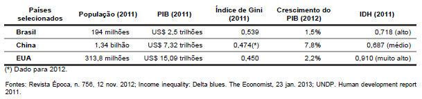
Com base na tabela e nos conhecimentos de Geografia, assinale a alternativa correta.
Sobre esses processos, considere as seguintes afirmativas:
1. Os escorregamento consistem em importante processo natural que atua na dinâmica das vertentes, fazendo parte da evolução do relevo terrestre, principalmente nas regiões serranas.
2. Nos grandes centros urbanos, os escorregamentos assumem frequentemente proporções catastróficas, uma vez que cortes nas encostas, depósitos de lixo, entre outras ações promovidas pelo homem geram novas relações com os fatores condicionantes naturais.
3. É necessário que o ser humano deixe de devastar as florestas, impermeabilizar os solos e contaminar os rios para que não mais ocorram os escorregamentos.
4. A origem vulcânica do relevo brasileiro gerou um conjunto de serras propícias para os escorregamentos, que acarretam grandes prejuízos e perdas significativas, inclusive de vidas humanas.
Assinale a alternativa correta.
Mas o fato de que se tenham instalado na fronteira tem grande impacto social e econômico. Em alguns distritos fronteiriços, como Nueva Esperanza ou Canindeyú, 58 e 83% dos proprietários são brasileiros, respectivamente. Isto facilita o contrabando e o controle da segurança das fronteiras, que é estratégica para a soberania de um país. Esse processo de ocupação territorial dilui as fronteiras a favor do país e do Estado mais poderoso e enfraquece ainda mais o país que tem cada vez menos instrumentos e capacidades de controlar sua riqueza. (ZIBECHI, Raúl. Brasil potência. Entre a integração regional e um novo imperialismo. Rio de Janeiro: Consequência, 2012, p. 257-258)
A partir do texto acima e dos conhecimentos de Geografia, considere as seguintes afirmativas:
1. O texto destaca a importância da presença de produtores brasileiros de soja para o crescimento econômico do Paraguai.
2. O texto mostra a importância que a produção agrícola tem na dinâmica da geopolítica mundial.
3. Na fronteira entre Brasil e Argentina a situação se inverte: são os argentinos que ocupam percentagens altas das terras aráveis brasileiras mais próximas da linha de fronteira.
4. A expansão internacional dos produtores agrícolas brasileiros não acontece apenas no Paraguai, mas também em países como Bolívia, Uruguai e Angola.
Sobre as origens e características do Estado, é correto afirmar:

Cada quadro na legenda, de 1 a 6, no mapa, representa um domínio morfoclimático. Numere as caracterizações abaixo, estabelecendo sua correspondência com a legenda do mapa.
( ) Domínio dos planaltos de araucárias, com predomínio de drenagens perenes e solos diversificados.
( ) Domínio dos chapadões recobertos por cerrados e penetrados por florestas de galerias, composto por planaltos de estrutura complexa, capeados ou não por lateritas de cimeira, planaltos sedimentares com vertentes em rampas suaves, drenagens espaçadas pouco ramificadas.
( ) Domínio das terras baixas florestadas com planícies de inundação labirínticas e/ou meândricas, tabuleiros extensos e morros baixos e arredondados nas áreas cristalinas adjacentes, terraços de cascalhos e/ou laterita, rios com elevada carga de sedimentos e drenagens perenes.
( ) Domínio das depressões interplanálticas semiáridas, revestido por diferentes tipos de caatingas, apresenta fraca decomposição das rochas com frequentes afloramentos, chãos pedregosos e drenagens intermitentes.
( ) Domínio das pradarias mistas, coxilhas extensivas, grandes matas subtropicais, apresenta fraca decomposição das rochas e presença de banhados.
( ) Domínio dos mares de morros florestados, apresenta fortíssima e generalizada decomposição de rochas, densas drenagens perenes, extensiva mamelonização.

 Conheça nossos planos